Monday, September 16, 2019

How to protect transit service from the next recession

During the last recession, cuts to transit service left people without a safe, reliable, or affordable way of getting where they need to go. (Photo courtesy of St. Louis Post-Dispatch)
Even though public transportation didn’t cause the late-2000s recession, transit riders were devastated by the service cuts that resulted from it.

Now, as we near the end of another decade, economic indicators are pointing to the strong possibility of another recession. When the next recession does occur, transit providers – and the elected officials, from federal to local, who allocate funding to them – must prove that they’ve learned to weather it. If properly sustained, transit connectivity could even help soften the next recession’s blow to the public and protect our society from further harm.

The auto industry recovered from the recession. Why didn’t transit?

Transportation policy implemented as a response to the 2008 recession did protect certain jobs and benefit communities that otherwise would have faced greater short-term challenges than they did. But this policy also entrenched the shortcomings of our present-day mobility, as automobile interests enjoyed the lion’s share of the rewards from taxpayers.

For decades, the likes of General Motors and Chrysler had prioritized manufacturing of SUVs and pickup trucks, which earn the companies higher per-vehicle profit margins than standard automobiles despite their poor fuel efficiency. However, during the 2000s, gas prices rose and, though the prices remained well below actual fuel costs, consumers not only embraced smaller cars produced by foreign companies, but also rode transit in steadily rising numbers through the middle portion of the decade.

Predictably, the auto industry found itself in a quagmire when the recession hit.

However, because a lot of people work for car companies, the federal government gave the companies an $80 billion bailout ($12 billion of which was never paid back) to preserve the employment they provide. Additionally, to create construction jobs, $27.5 billion in stimulus funds went to the country’s road and highway system, which carries the cars the bailed-out corporations build.

Transportation modes that don’t involve cars did see support, but not to the same degree. The stimulus package included $8.4 billion for local transit and $9.3 billion for intercity rail.

The vast majority of the local transit funds were restricted to capital projects, rather than system operation. Accordingly, even as transit providers purchased new vehicles and built new tracks, they couldn’t afford to sustain their existing networks as the state and local funds their operating budgets depend on dried up due to the slow economy.

Deep cuts to transit service resulted, stunting ridership and revenue. Specifically, nearly three-quarters of U.S. transit agencies had either implemented or were considering service cuts by 2010. For example, the Pittsburgh area’s Port Authority of Allegheny County eliminated 15 percent of its bus service hours in March 2011. Los Angeles Metro, despite its ambitious rail goals, slashed 10 percent of its bus service, most of which it never restored.

Much of the intercity rail funding, meanwhile, fell victim to the polarized political environment surrounding U.S. transportation. Following elections in 2009 and 2010, nearly inaugurated governors Chris Christie (NJ), Scott Walker (WI), Rick Scott (FL), and John Kasich (OH) all cancelled large-scale rail projects and returned the federal dollars intended for them. The largest project to survive – California’s under-construction high-speed rail line – has also proceeded more slowly than it should have, largely due to lawsuits and political bickering.

Public transportation doesn't just provide connectivity. It puts people to work. (Photo courtesy of MPR News)
Though U.S. auto companies promised to focus more on vehicle fuel efficiency at the time they were bailed out, today they’re once again prioritizing SUVs and trucks in pursuit of profit. People who drive those vehicles still have to worry about sudden oil shocks stemming from Middle East strife. In the meantime, transit systems remain underutilized, underfunded, and stigmatized.   

Thus, when the next recession hits, public transportation should be treated as an essential form of connectivity that’s vital to the economy, rather than something that can simply be tossed aside in an attempt to balance a budget. 

Policymakers at all levels of government can take steps to ensure this happens.

A federal focus on underdeveloped parts of our transportation system would create jobs, both directly and indirectly

Over a half-century of federal appropriations have shaped how U.S. transportation infrastructure – and, accordingly, U.S. transportation culture – looks today. In the 1950s, our country’s leaders decided to construct a state-of-the-art highway network, and thanks to decades of sustained commitment, they succeeded. Though our roads and highways – in contrast to our transit – are now more or less built out, roads continue to receive four times as much federal formula funding as transit does.

The next recession’s stimulus package should put people first, prioritizing frequent, reliable transit over special interests and politics, as follows:

Increase capacity while preserving space: Road expansions don’t make it easier for people to get where they need to go, as added capacity is quickly consumed by more cars. Fortunately, there is a more effective and less disruptive way to increase capacity: re-purposing existing road space.

Protected bike and pedestrian infrastructure gives people more options for short trips – over 45 percent of present-day car trips are three miles or less in length – while dedicated transit rights of way provide a more reliable, less stressful way to reach destinations both near and far. There would also still be street space for people who drive, who would wind up at least as well off as if roads were widened.

Like road expansion projects, re-purposing of street space requires construction – creating jobs in line with a stimulus package’s objectives – but taxpayers would get much more bang for their buck. For one, dedicated transit lanes facilitate faster service, which boost a system’s financial performance through a combination of increased ridership and reduced operating costs. Benefits would extend beyond just improved connectivity, as mobility would become safer and healthier, public spaces would become more inviting, and we’d breathe cleaner air while making progress toward greenhouse gas emission reduction goals. 

Fund high-quality mobility, not just infrastructure: While transportation systems require infrastructure, vehicles, and other capital assets to function, effective mobility requires more than just steel and cement. For automobile-based modes, non-infrastructural necessities include car companies’ manufacturing, sales, and marketing arms; public-sector regulators who ensure cars adhere to safety and environmental standards and drivers are qualified to be behind the wheel; police who enforce the rules of the road; and first responders who save lives when cars crash.

Similarly, public transit systems require operating funds in order to connect people to their jobs, errands, medical appointments, and other life needs. Thus, in order for the next transportation stimulus package to tangibly benefit the public, a substantial portion of the funds must go toward transit operation.

As labor typically constitutes at least 70 percent of a system’s operating costs, the majority of this funding would be injected straight into the economy, sustaining stable, well-paying jobs. Other beneficiaries of the funds would include producers of the electricity, natural gas, and diesel that fuel our transit systems, as well as the fleet maintenance programs that keep those systems safe and reliable.    
  
Give states and localities flexibility, but make sure they stick to their plans: Since the last recession, another powerful car-based transportation industry has arisen: app-based ride-hailing.

Ride-hailing, like public transit, typically doesn’t earn enough revenue from fares to cover its operating costs. Infusions of venture capital – largely from traditional auto and oil companies – covered the industry’s losses for years. But now that the likes of Uber and Lyft are publicly traded, they’ll have to demonstrate they can earn profit to sustain stable operations. This will be challenging for them, especially if a recession strikes.

However, as ride-hailing gigs have become a source of income for many – Uber alone has an estimated 1.5 to 2.5 million drivers in the U.S. – it’s possible that, in the case a recession pushes the industry to the brink, firms will lobby for a federal bailout comparable to that the auto industry received in 2008.

However, driving for a ride hailing company is much different than working for a car manufacturer – while the latter provides relatively stable jobs, the former refuses to consider its workforce employees. In addition, it’s debatable whether the transportation ride-hailing companies provide, which has worsened traffic congestion and experienced significant safety issues, has benefitted our mobility. 

Thus, it should be up to states and localities to determine how ride-hailing should fit into their transportation networks, as well as how, if at all, taxpayer dollars should be used to optimize that fit. There’s already evidence that ride-hailing firms see contracts with transit providers as a path to profitability – a direction that would put them into competition with traditional transit contractors such as Transdev and First Transit, rather than transit systems themselves – and a recession may force them to restructure their operations more exclusively to that end. Metropolitan areas may be particularly interested in bolstering ride-hailing firms’ bike- and scooter-share arms, which in some cases have proven more popular than their car services.

But for larger-scale capital projects, states and localities that receive stimulus transit funds should be required to use those funds to achieve the objective they were intended for. Uncertainty stemming from political manipulation, such as that which stalled rail projects in 2009 and 2010, makes it incredibly difficult to plan and construct an effective transportation network. Thus, while practical adjustments to projects are a natural part of the planning process, any jurisdiction that opts to return already-obligated transit or intercity rail funds to the federal government without sufficient reason should be required to forfeit not just those funds, but also an equivalent portion of their formula-based highway allocation.

States and localities must embrace long-term goals

Though the above-described federal-level steps would catalyze widespread benefits, states and localities that wait for Congress and the president to act risk being let down. Fortunately, they also can take steps, independent of what happens nationally, to preserve and improve their mobility while bolstering their economies and creating jobs, as follows:

Consider the social, economic, and environmental impacts of service cuts: Before they can be built, proposed transit expansions must undergo extensive environmental review. This process can take years, and often becomes a tool transit opponents use to file lawsuits and stall much-needed projects.

Service cuts, on the other hand, are much easier to implement. Typically, a transit agency facing fiscal challenges will release a list of routes slated for elimination or reduction. They’ll then hold a couple public hearings at which riders of these routes can plead for mercy; the agency may then back off the original proposal slightly, but will still lay down the hammer in the end.

Title VI of the federal Civil Rights Act is one of few viable existing tools that transit advocates can use to fend off service cuts. But in order to be stopped using this mechanism, a cut must constitute obvious discrimination against minority or low-income riders – a high and unclear threshold. Typically, a transit agency can submit a back-of-the-envelope equity analysis to fulfill Title VI requirements; failure to conduct the proper analysis may result in a Federal Transit Administration request for more analysis, but actual service restoration is much less likely. Even if the analysis finds a proposed cut does constitute discrimination, the cut may just be restructured, rather than rescinded.

But service cuts cause much more serious environmental and social harm than a transit expansion. Thus, they should be subject to a review process that’s at least as stringent. A thorough analysis of a proposed cut’s impact on automobile vehicle miles traveled (VMT) and associated costs – such as fuel, maintenance, crashes, congestion, and emissions – would be a start. A more sophisticated process could extend beyond VMT analysis to also look at trips that simply wouldn’t happen if a proposed cut to transit was carried out, and the lost wages, time, and other adverse economic impacts that would result.

A more stringent review process protecting against transit service cuts could lead to numerous positive impacts for the public, including:
  • The costs of the review process could discourage officials from defaulting to transit service cuts and instead seek less harmful ways to balance the budget.
  • To create some middle ground, officials could streamline the environmental review standards transit expansions are held to, lowering those expansions’ costs and making them a more attractive recipient of future stimulus funds
  • In the long term, officials could analyze the reviews to quantify the level of transit service needed to provide adequate connectivity to residences, places of employment, and other life needs, establishing a sustainable transportation equivalent to automobile level of service (LOS) metrics.   

Align transit and land use to meet peoples’ needs: Service cuts are a form of corporate downsizing – transit officials hope to reduce costs while minimizing losses to revenue. Though systems are typically not designed to maximize ridership (such an approach would leave people who live in outlying areas without sufficient service), officials often cite ridership numbers when attempting to justify cuts. 

However, cuts make transit less competitive with other transportation options, causing ridership – and revenue – to decline sharply. As a result, transit providers often fail to achieve their budget-balancing goals through downsizing and may even resort to further cuts, furthering a destructive cycle.

Fortunately, there is a better option – strategies that boost revenue with only nominal effects on costs, in effect reducing the subsidies needed to provide transit service. There are two, interrelated ways of doing this: re-aligning transit networks to better match modern-day demand and adjusting land use policy to better integrate transit systems into the neighborhoods they serve.

Numerous regions have redesigned their bus systems in recent years, making them a more convenient way to get around amidst an increasingly competitive transportation sector. A recession would further push localities, especially those that have not yet pursued system redesigns, to re-discover the role of their transit systems:
  • Serve more than just 9-to-5 commutes: One of a transit system’s tasks is to move day-shift commuters from residential areas to employment centers in the morning, then back in the afternoon. However, such trips are just a portion of the connectivity people need. Across industries, workers’ shifts start and end throughout the day and night, and everyone also has 24-hour-a-day lives that involve a lot more than just their jobs. During a recession, when a relatively high portion of the population may be out of work and require transportation primarily for errands and their job searches, non-workplace connectivity is particularly essential.  
  • Keep up with expanding metropolises: Excessive sprawl presents a litany of challenges for transit providers. Perhaps the most pressing of these challenges is that if a metropolitan area expands outward, but the transit system doesn’t expand with it, the system will serve a smaller portion of peoples’ travel needs, leading to a decline in ridership even as population expands. Requiring new development projects to incorporate adequate transit connectivity, perhaps through a mechanism such as the sustainable equivalent to automobile LOS described above, would help mitigate this challenge and sustain revenue.
  • Put efficiency ahead of trendiness: In response to the rise of ride-hailing apps, a number of transit providers have made efforts to incorporate technology-based transportation into their systems. Some have directly subsidized certain types of trips on external ride-hailing networks, while others have started up their own internal app-based van services. In several cases, however, these programs have come at the expense of continuing or improving fixed-route bus service. Given that even the lowest-performing fixed routes typically move more people than ride hailing-style replacements for those routes, transit providers should thoroughly consider impacts to ridership and revenue, looking at alternative approaches (such as simply tweaking the alignment and stop locations of coverage-oriented fixed routes to provide more effective mobility) rather than blindly trying to keep up with ever-changing transportation trends.  

A transit system’s performance is influenced not just by the alignment of its routes, but also by the built environment that surrounds those routes. The adverse effects that common zoning regulations such as restrictions on height, use, and density, as well as parking minimums and car-based impact fees, have on transit ridership and revenue are well-known. Re-thinking these regulations helps broaden a system’s ridership base and, accordingly, its farebox recovery. In some cases, a transit provider can redevelop land it controls and even capture some of the value a system’s connectivity adds to the development projects surrounding it, further reducing the need for taxpayer subsidies.

More subtle tweaks to the built environment also can greatly increase the usefulness and performance of a transit system. Such tweaks include low-cost improvements to the places where riders board transit, such as installation of benches, shelters, and real-time arrival information, as well as ensuring people have safe, direct ways to walk or bike to transit stops.   

Act in the interests of people who ride transit: Public transportation agencies find themselves so vulnerable to short-term trends in part because some of the officials who govern our systems rarely ride them, and thus may not fully understand the role of transit connectivity in a person’s life. Given the power they have over an agency’s budget, such officials may be quick to resort to a service cut not because it furthers the system’s interests (as mentioned earlier, cuts are at best only a stopgap solution to an agency’s underlying financial problems) but rather because their power allows them to check a box that satisfies other, non-mobility interests.

Transit providers could address this issue by restructuring their boards or other means of governance to better represent riders. When budgetary challenges arise, rider-representative leaders would be more likely to focus on addressing the systemic issues that underlie funding shortages, rather than just cutting service. Also, to the extent that any changes affecting transit riders are necessary, such leaders would strive to implement them in a more equitable and user-friendly manner – for example, implementing a fare increase without making rider-hostile changes to the overall fare structure such as eliminating inter-route transfers. 

A transit-focused stimulus would make long-term life better

The benefits of preserving and improving transit service through a short-term recession would extend beyond just the immediate connectivity that service provides.

Good transit service makes it easier for people to access jobs, employers to recruit workers, and businesses to attract customers. All of these interactions help stimulate the economy, helping offset the negative effects of a broader downturn. In addition, for each new car people don’t feel compelled to purchase due to availability of better mobility options, more than $9,000 per year is freed up for people to spend in their communities, providing a boost for localities big and small, urban and rural.

Good transit service also represents a basic regard for life. Car crashes are not only lethal to people in vehicles, but also to people on foot or bicycle that have to share the streets with them.  Accordingly, minimizing the need to use and interact with cars gives people an opportunity to avoid this danger and maximize their contributions to the world.

And finally, good transit service today will help us sustain our civilization. If climate change is allowed to proceed unabated, the resulting harm to our economy and quality of life will eclipse anything our society has experienced in recent memory. Transportation is the U.S.’s biggest source of greenhouse gas emissions, and automobiles the biggest contributor to that source, so sustaining and bolstering transit – and the superior connectivity it provides – is perhaps the best way to reduce those emissions.

Saturday, August 3, 2019

An Alabama town’s ugly transportation past resurfaces in Hong Kong

Areawide Community Transportation System (ACTS) buses take on passengers at Anniston, AL's Amtrak station in July 2019. 58 years earlier, a Ku Klux Klan mob attacked the first racially-integrated intercity buses to serve the town. (Photo by me) 

Staring out the window of Amtrak’s New Orleans-bound Crescent train as it entered Anniston, AL on a recent Saturday, I caught a view of New Flyer of America’s recently-expanded bus factory.  The New Flyer factory gives Anniston, which lost 5.8 percent of its population from 2010 to 2017, a much-needed economic boost.

Transit agencies throughout the U.S. – including New York City Transit, whose Select Bus Service buses lined the facility as our train rolled past, and the Maryland Transit Administration, which recently spent $81.3 million on New Flyer buses now operating in Baltimore – supply funds that the factory’s 750 workers pass on to local businesses. 

A couple minutes past the factory, on the other side of the tracks, stood one of those businesses: an awning supply shop with two large Make America Great Again signs on its storefront.

As we pulled into Anniston Station, where Areawide Community Transportation System (ACTS) buses were taking on riders, I recalled the events of my prior trip on the Crescent, two years ago. That 2017 spring day – with DC Circulator buses lining the New Flyer facility – our train stopped just beyond Anniston due to a disabled Norfolk Southern freight train blocking the tracks ahead. We sat still for more than two hours before the conductor, having given up on a quick resolution to the problem, ordered our train back to the station, where we remained until the freight train was finally fixed.

A white passenger accosted a black Amtrak employee in the café car while we sat just west of town during that delay, exclaiming in a thick Southern accent that “everything’s wrong” while begging to be let off the train so she could drive to Birmingham, the next stop, for her afternoon religious service.

Greyhound buses in Birmingham, AL, as seen from Amtrak's Crescent train. (Photo by me)
In the spring of 1961, a lot was wrong in Anniston.

Six years earlier, the Interstate Commerce Commission had issued a ruling banning racial segregation on intercity transit, but had done nothing to enforce the ruling. So, the Freedom Riders – a mixed-race group of civil rights activists – took matters into their own hands, choosing their seats for a DC-to-New Orleans bus trip paralleling the Crescent route of today.

On Mother’s Day, a Greyhound with Freedom Riders aboard pulled into Anniston, the first of two passenger-desegregated buses heading into Alabama that day. However, a Ku Klux Klan mob – some members of which were clad in attire they had worn to religious services earlier that Sunday – attacked the bus during its stop at the downtown terminal, slashing its tires. Police, operating in collusion with the KKK, did little to restore order.

The bus made a quick departure, but only made it a few miles west of town before the Klan-inflicted damage rendered it disabled. The KKK mob, which has followed in pursuit, attempted to burn the bus with the riders trapped inside, then brutally beat them once they escaped. The riders made it to a local hospital, but received only minimal care as the mob surrounded the medical facilities. Allies from Birmingham had to come and rescue them, using a fleet of vehicles.

Freedom Riders aboard the second bus, which operated as part of the then-Greyhound competitor Trailways Transportation System, faced similar terror during their Anniston stop. Klansmen boarded, beat the riders to near unconsciousness, and dragged them to the back of the bus. The bus then continued to Birmingham, where upon arrival an even larger mob proceeded to beat the passengers with bats, pipes, and chains.

Despite the violence people aboard those first desegregated buses faced, Freedom Rides would continue for months. Later that year, the movement would catalyze a major Civil Rights accomplishment: full, enforced racial integration of intercity public transportation in the South.

Amtrak's Crescent passes wetlands near Lake Pontchartrain. (Photo by me)
58 years later, the Crescent would not be delayed in Anniston on this day. After a stop at the station – which now doubles as the town’s Greyhound terminal – that seemed shorter than the length of time it takes for the doors to open on a WMATA 7000-series train, the whistle sounded and we were on our way to Birmingham. (The downtown bus terminal at which the Freedom Riders were attacked still stands, preserved as part of a national monument President Obama established.) 

Shortly thereafter, I would – by the type of happenstance that can only happen in an Amtrak dining car – have lunch with Chef Madison Butler, the Rail Passengers’ Association intern spending the summer on a food-inspired cross-country rail trip, during her ride from Atlanta to Meridian, MS. That evening, stunning views of Lake Pontchartrain welcomed us into New Orleans, an hour behind the published schedule but on time for dinner at Acme Oyster House and a night of live music on Frenchmen Street.

A Lyft car at the front of a line of stopped vehicles near Frenchmen Street in New Orleans. (Photo by me)
I would encounter a spontaneous outdoor brass-band performance, on a street congested with ride-hailing vehicles. The chaos served as a reminder that the current state of mobility in New Orleans represents some of U.S. transportation policy’s greatest shortcomings – substantial funding went into construction of the short-line, mixed-traffic Loyola-Rampart Streetcar, but bus service levels remain approximately half what they were prior to Hurricane Katrina in 2005.

But on the other side of the globe, in a city-state that those of us trying to make it easier for people to get around places like New Orleans are infatuated with, a scene bearing eerie similarities to the KKK’s attacks on the Freedom Riders was playing out in a subway station.

Handmade signs implore drivers in New Orleans's Lower Ninth Ward, one of the hardest-hit neighborhoods during Hurricane Katrina, to slow down. Though 14 years have passed since the storm, the city has restored just half of its bus service. (Photo by me)  
Hong Kong’s Mass Transit Railway (MTR) is one of the world’s best transit systems. The city’s Rail + Property Model has both allowed the Hong Kong Stock Exchange-listed MTR Corporation to reinvest economic benefits the system provides city residents and businesses into further transit improvements, while also integrating stations and their surrounding neighborhoods so effectively that the system operates profitably. MTR has garnered such respect that transit providers from Sweden to Australia have contracted their operations to them.

On July 21, 2019, however, MTR’s Yuen Long Station looked a lot like Anniston’s bus terminal did on Mother’s Day 1961.

That day, hundreds of thousands of people had ridden MTR trains to attend the latest in a series of large protests against what they see as increasingly authoritarian behavior by the mainland Chinese government. Much like the Women’s Marches in U.S. cities the day after Donald Trump’s inauguration and the demonstrations in Seoul that catalyzed the impeachment of former South Korean president Park Geun-Hye, transit’s efficiency helped make Hong Kong’s massive gathering happen.

But after the rally, a white-clothed pro-China mob attacked riders aboard a packed train stopped at Yuen Long.  Using metal and wooden rods, the mob did not just attack people headed home from the protest, but beat those aboard indiscriminately. They injured people commuting home from late-evening work shifts, and even a pregnant woman.

Police did not arrive until a half hour after the attack, which an organized crime group carried out. Though local officials stated that the ongoing demonstrations had strained law enforcement resources, activists saw the slow response as evidence that those in charge knowingly allowed the mob violence to happen, much as Anniston authorities conspired with the KKK to terrorize the Freedom Riders.      

A New York City Transit bus at New Flyer of America's Anniston, AL factory. (Photo by me)
From Alabama towns to Asian megacities, public transportation gives people freedom of mobility. And in both, oppressive forces have resorted to violence against transit riders. The attackers in Hong Kong and Anniston had the same goal: to restrict the public’s freedom and spread fear.
          
Historically, when oppressors try to take on transit riders, they fail. In 1961, the KKK’s terror only steeled the resolve of the Freedom Riders, helping thrust the Civil Rights Movement into the national spotlight.

MTR now finds itself in a position comparable to that the American South’s intercity bus carriers did – a flashpoint of a major social and political movement. Earlier this week, protesters blocked train doors during a morning rush hour to express their condemnation of the attack, leading to crippling delays and bustitutions on the normally impeccable rail system. There’s also been talk of a train operators’ strike, which would likely cause even greater service disruptions.

It remains to be seen what long-term impact the Hong Kong demonstrations will have. But one thing is certain: violent mobs won’t scare people away from riding transit, or from fighting for what they believe in.          

Sunday, June 16, 2019

Transit is helping Yosemite address its big-city transportation challenges

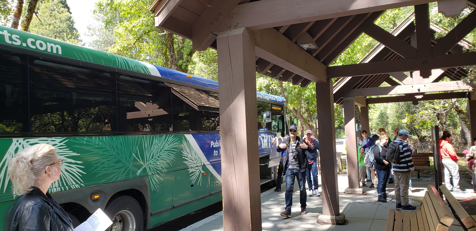
A Yosemite Area Regional Transportation System (YARTS) bus in Yosemite Valley. (Photo by me)
Because Yosemite National Park isn’t in the middle of a densely populated city, many in the U.S. transportation industry would say only bare-bones, lifeline transit service (if that, even) is necessary there. In contrast to DC’s Rock Creek Park, Yosemite lacks a rail system that people who climb El Capitan can use to get back to the bottom of the cliff.  

But a lot of people want to experience Yosemite’s world-class hiking, stunning vistas, and unique alpine scenery. And in recent years, it’s become clear that when too many of the California park’s five million-plus annual visitors attempt to access the park by car, all they’ll experience is misery. During peak periods, drivers can spend hours staring at taillights, only for park rangers to turn them away from the most popular areas before they can even exit their vehicles.

The geometric factors behind the park’s congestion problems mimic those that plague overly auto-dependent cities. Paving over meadows, forests, and streams to build more traffic lanes and parking lots wouldn’t alleviate the crush of cars, though some would-be visitors may find there’s plenty of asphalt to explore in their local strip mall and not even bother to make the trip.

Instead, the solution – just as in cities – is to prioritize more spatially efficient forms of mobility.

The basic elements of this solution are already in place. Core-capacity shuttle services carry per-mile ridership comparable to the country’s busiest transit systems, the regional Yosemite Area Regional Transportation System (YARTS) bus network covers all of the park’s main roads, and walking remains the only way to access backcountry areas.

Improving these options – which I utilized on a recent trip to the park – is the only way to ensure we can preserve and enjoy this precious national treasure.

Most of Yosemite is car-free, and always has been

A view of Yosemite Valley from the Yosemite Falls Trail. (Photo by me)
Despite the traffic congestion plaguing Yosemite Valley (where well-known landmarks including Yosemite Falls, El Capitan, and Half Dome are located) the vast majority of the national park is not accessible by car. The National Park Service (NPS)’s ingenious transportation demand management strategy: not building roads.

Instead, visitors must use the park’s 800 mile network of backcountry trails – which includes portions of the famous Pacific Crest and John Muir trails – to get to Yosemite’s most pristine areas. The trails feature plenty of strenuous sections, but also amenities that would make people in car-choked urban areas envious.

For example, though the top of Half Dome would only be accessible to skilled rock climbers in its natural state, two 400-foot-long cables lining the steepest section of the walkway make it possible for regular hikers to reach the summit. Though the trek still requires strength and stamina, at least hikers on Half Dome – in contrast to cyclists on most city streets in the U.S. – have something more than paint protecting them.

NPS also maintains six High Sierra Camps, each situated along remote sections of backcountry trail. These small communities, catering exclusively to people on foot or horseback, offer hikers cabin lodging and meal service. However, the camps’ accessibility is largely dictated by nature – this summer, for the second time in three years, the facilities won’t operate due to unusually heavy snowfall that prevented employees from conducting pre-season maintenance activities.

To allow visitors “outstanding opportunities for solitude,” NPS regulates Yosemite backcountry mobility much more strictly than it regulates automobile travel in the park (or on DC’s Rock Creek Parkway). Backpackers planning overnight stays in the wilderness must reserve permits months in advance to guarantee access to the highest-demand trailheads during peak tourism periods. Most day hikers are exempt from permitting requirements, though those wishing to attempt the aforementioned Half Dome hike must win a highly competitive NPS lottery before setting foot on the mountain.

Where there are roads, there’s bus service 

A Yosemite Valley shuttle bus crosses a congested road. (Photo by me)
As the acting director of NPS in early 2017, Michael Reynolds fielded an angry phone call from Donald Trump after the agency retweeted photos showing the sparse size of the president’s inauguration crowd. Now, as the superintendent of Yosemite, Reynolds is in charge of the park’s efforts to safely and efficiently handle its record-breaking crowds.

In a 2018 interview with the Fresno Bee, Reynolds provided an excellent summary of the transportation-geometry relationship, explaining that it’s not the large number of visitors to Yosemite Valley that’s the problem, but the fact that many of them are using a form of mobility that there simply isn’t space for.

“The issue here is cars,” the Bee quoted him saying. “An awful lot of cars in a small space, all at one time.”

Reynolds was oddly defeatist, however, when discussing the possibility of better transportation options. According to the Bee article, he said the park “does not have the infrastructure” for a regional bus system providing connectivity between the valley and communities outside the park. He also cringeworthily told the San Francisco Chronicle that an “Uber culture” could help solve the park’s traffic problems.

A Sonora-bound YARTS bus ascends a hail-covered road out of Yosemite Valley. Good thing we weren't driving! (Photo by me)
Fortunately, the superintendent doesn’t need to design a completely new bus system – because one is already there. He’d be well-advised to try that system – YARTS – out sometime.

YARTS started service in 2000, and originally was primarily a lifeline transportation option for park employees. The system, whose four routes operate between Yosemite Valley and the termini of Merced, Fresno, Mammoth Lakes, and Sonora (serving towns, trailheads, and lodging along all of the park’s main roads), still fulfills that essential role. But as it has expanded, park visitors have also used it more and more, with ridership up 50 percent over the last 14 years. Today, more than 100,000 people ride YARTS annually.

Over Memorial Day weekend, I took a day trip on the Sonora route from Rush Creek Lodge (a hotel just outside the park entrance) into Yosemite Valley. Our hour-long mid-morning ride in went smoothly, with the exception of a brief delay to let a bear cross State Route 120. A bus lane through congested portions of the valley aided our travel.

We then hiked for several hours, making it much of the way up the Yosemite Falls Trail. But as we finished our packed-in lunches, thunderclouds loomed. We quickly descended the exposed, switchbacked trail, caught a circulator bus, and headed into The Loft at Degnan’s for a couple beers before catching our afternoon bus back to Rush Creek. By the time we boarded, the weather had deteriorated, but our bus driver calmly and safely ascended the grade out of the valley through an intense hailstorm.  
     
YARTS operates using intercity-style coach buses, with restrooms on board and space for luggage such as hiking and camping gear. Riders can pay their fares when they board – as we did – or can reserve a seat in advance. During particularly busy times of year, the transit system waives fares on some days.

YARTS has made efforts to integrate its transit services with those of peer transportation providers. At the stop in Yosemite Valley, riders can transfer to the aforementioned circulator shuttle system, which has two routes, serves numerous popular destinations, and is fareless. The shuttles are quite crowded, carrying nearly 4,000 passengers per mile of route length – a load factor comparable to that of San Francisco’s Muni. The valley also offers a network of separated bike-pedestrian paths and – starting last year – a dockless bikeshare system.

Outside the national park, YARTS connects to several other regional and intercity transit systems. Riders transferring from Amtrak’s San Joaquins train route (in Merced and Fresno) and Greyhound buses (also in Merced) can purchase through tickets, facilitating travel from locations such as Los Angeles, San Francisco, and Sacramento on a single fare. Also, YARTS offers United Airlines passengers free transfers to YARTS’s Fresno and Mammoth Lakes routes, encouraging visitors flying into Yosemite’s two closest airports that serve major airlines to take the bus to the park. 

And starting next decade, existing YARTS bus routes will connect to the initial operating segment of California’s currently under-construction high-speed rail system in Merced and Fresno, as well as to a Merced extension of the Altamont Corridor Express (ACE) rail system.  
      
While Yosemite has plenty to learn, in the future cities may also learn from Yosemite

Despite all the progress YARTS has made over the last two decades, only two percent of Yosemite visitors arrive by transit, demonstrating that there is a lot of room for improvement.

The existing YARTS system is designed primarily to get people to and from Yosemite Valley, and its timetables strongly resemble those of “commuter” rail or bus systems intended to give people living in outlying parts of metropolitan areas an "alternative" way of getting to and from downtown, with the valley taking the place of the city center. As a result, it can be challenging to plan a transit-based day trip to other must-see (though less car-congested) parts of the park, such as Tuolumne Meadows or Mariposa Grove. Also, the YARTS system is largely seasonal – only the Merced route operates year-round, with service on the other three routes limited to the peak late spring, summer, and early fall tourism periods.

Furthermore, infrastructural issues outside of YARTS’s control limit its ability to serve the region. For example, while (as mentioned earlier) there are bus lanes in Yosemite Valley, there are no such lanes at the park entrances, rendering passengers susceptible to delays caused by long queues of single-occupancy vehicles. Also, NPS does not plow Tioga Pass Road – which carries the Mammoth Lakes route – during snowy periods, preventing YARTS from providing a valuable connection between Yosemite Valley and the famous Mammoth Mountain ski resort during the winter. And the fastest road for automobiles up the Priest Grade, a segment of the Sonora route, is very steep and not maintained to standards adequate for bus service, forcing YARTS riders onto a windier, more circuitous road that’s ten minutes slower.

The view from Rush Creek Lodge, located just outside Yosemite, after a late-May snowstorm. High-elevation weather patterns pose a challenge to transit providers. (Photo by me)
Despite these challenges, plenty of factors indicate a promising future for YARTS.

For one, despite the small percentage of Yosemite visitors that arrive via transit buses, the portion entering the park on any type of bus – including charter buses – is a much greater 9 percent of total entrants, or about 500,000 people. Many of the charter bus passengers could well prefer to take transit – which should offer them more freedom than a guided tour – but may not know YARTS is an option, or may not find the system sufficiently frequent or extensive to meet their needs.

In some ways, YARTS has more going for it than urban transit agencies do. Specifically, improvements to transit in Yosemite – such as increased service frequencies, more year-round service, and routes and schedules designed to facilitate access to all parts of the area roads serve (rather than just Yosemite Valley) – may be less susceptible to the three primary types of harmful transit opposition, as follows:

Car culture:  The auto industry has had a strong influence on American transportation culture, and as a result cars seem to dictate everything from the way our infrastructure is engineered to a person’s social status. Accordingly, many people are hesitant to embrace other methods of getting around.

However, Yosemite is a place people – from urbanists to car aficionados – go to experience the outdoors, not to sit in traffic. For hikers and backpackers, it can be preferable to start and end a trip at different locations (possible by transit) than to return to the origin (required if driving). Furthermore, in contrast to many city centers, people are already accustomed to paying to drive into Yosemite, so tools such as congestion pricing could be framed as beneficial tweaks to the existing toll system. 

NIMBYism:  In metropolitan areas, transit projects connecting major activity centers often face opposition from local residents and business owners who fear change or believe in false stereotypes. This opposition often causes projects to be scaled back, rerouted to the point that their would-be benefits are largely negated, or even cancelled entirely.

But despite how crowded Yosemite can get, only a small number of people live there. Environmental preservationists concerned about impacts on local resources will likely welcome transit improvements and other changes that could reduce driving and help sustain the park’s scenery, rather than oppose those improvements on NIMBY grounds.

Also, in spite of the park’s superintendent’s aforementioned Uber references, the area’s small population and spotty cell phone service render congestion-worsening ride hailing impractical.  

Funding:  New transit infrastructure is expensive to construct, especially in the U.S, and it can be challenging to obtain the necessary funds. However, YARTS service increases would require primarily new buses and drivers, rather than new rights of way, reducing the potential of excessive scrutiny.

Furthermore, California already has relatively good intercity rail and bus service (by U.S. standards), so YARTS can take advantage of infrastructure elsewhere in the state. For example, YARTS hired a consultant to study the possibility of system expansions, but an extension to the San Francisco Bay Area was deemed unnecessary because a well-timed San Joaquins rail connection is already in place. The study instead recommended YARTS prioritize improvements on its existing routes and consider extending its Sonora route to Sacramento via Stockton, which would provide additional connections and help fill a gap in the state’s transportation system.

***

Transit can be a mainstream form of mobility in a national park. The strong ridership on Yosemite Valley’s circulator shuttle system, as well as a comparable local shuttle network serving Zion National Park in Utah (which began service the same year YARTS did, operates as frequently as every four minutes on largely car-free roads, and carries more than 6 million annual riders) demonstrates this.  

However, YARTS has the potential to be a primary way for people to both get to the Yosemite region and move around the region once there, exceeding the Yosemite Valley and Zion systems’ primarily local functionality. To expand transit’s role in the Yosemite area, officials should treat YARTS as they have the park’s backcountry trail network – as mobility, rather than just an alternative to driving and parking. 

If YARTS and the jurisdictions that govern it can seize this opportunity, they not only would help people rediscover Yosemite the way it was meant to be seen, but could also play a part in fixing mobility in other places. If people travel to Yosemite and have positive, car-free transportation experiences there, they may wish to replicate those experiences back home.


Sunday, May 5, 2019

North American border controls make international mobility challenging. How are transit providers coping?


Strasbourg, France's Line D tram, seen here in central Strasbourg, crosses the Rhine River to provide a one-seat connection to the center of Kehl, Germany. (Photo by me)

Within Europe’s Schengen Area, international borders are little more than what they actually are: lines drawn on paper. As a result, transit routes – from local bus and rail services to intercity high-speed trains – can cross these lines without having to slow down or stop.

Border officers have the authority to spot-check passengers’ travel documents, cell phones switch over to a different provider, and depending on the country it may be necessary to exchange currency. But for the most part, the experience is no different than crossing from one U.S. state into another.


For example, Strasbourg, France’s Line D tram crosses the Rhine River to serve Kehl, Germany. While the U.S. capital region struggles to find the funding for a second trans-Potomac Metro tunnel between DC and Virginia, a new trans-Rhine bridge (as seen in my video above) facilitated the line’s cross-border extension. For just a single flat fare, French residents can cross the border for refreshing beer, tasty schnitzel, and relatively inexpensive groceries, while Germans can enjoy Strasbourg’s idyllic canals and historic center or conduct business in the official seat of the European Parliament.

The San Ysidro border crossing facility separating San Diego and Tijuana looks quite a bit different than the tram bridge connecting Strasbourg and Kehl. (Photo courtesy of Times of San Diego)
In contrast to Western Europe, North American policymakers believe that, to ensure the public’s safety, it’s necessary for everyone who legally crosses an international border – be it by land, sea, or air – to stop, queue, and undergo inspection. There’s been a lot of talk about building a wall to mark one of the U.S.’s two land borders, but even at the other (longer) border, these inspections are mandatory for all crossers in both directions.

Even though each individual inspection typically doesn’t take long, at busy checkpoints those extra seconds add up and can cause hours-long waits in line. To make matters worse, many border crossing facilities are designed primarily for cars, and thus incorporate lots of asphalt, congestion, and pollution.

However, a few transit providers have found a way to facilitate functional mobility between the U.S. and Canada or Mexico. Though it’s impossible for these providers to match the efficiency of Schengen countries’ cross-border routes, their offerings do help mitigate the adverse impacts of inspections. Border regions with viable international transit options include San Diego-Tijuana, Detroit-Windsor, and Vancouver-Seattle.

San Diego-Tijuana: transit hubs and pedestrian infrastructure help bring two cities together

The trains don't continue south into Tijuana, but it's still a lot more convenient and pleasant to take transit to the U.S.-Mexico border's busiest crossing than it is to cross in a car. (Photo courtesy of KPBS)
Separating San Diego, California and Tijuana, Baja California, the San Ysidro border crossing is one of the world’s busiest. More than 30 million annual northbound travelers use the crossing to enter the U.S and, though exact data on southbound travelers is not readily available, a comparable number presumably use it to enter Mexico.

The crossing contains inspection facilities for both drivers and pedestrians, and more than a quarter of its users pass through on foot. As a result, public transit connections are essential to the facility’s functionality.

On the San Diego side, the Metropolitan Transit System’s Blue Line trolley (light rail) terminates at the border crossing facility. When U.S.-bound crossers step out of the main customs building, they’re literally on the San Ysidro station’s platform.

San Ysidro is MTS’s busiest non-transfer trolley station and during afternoon rush hour trains are typically packed all the way to the border, helping the Blue Line achieve a farebox recovery ratio of around 75 percent. Given that a transit trip from Mexico to Downtown San Diego takes about 30 minutes and a northward extension of the Blue Line to UC San Diego and the North University City job center is under construction, it’s no wonder that Club Tijuana Xoloitzcuintles de Caliente (the city’s Liga MX soccer team) refers to themselves as El Equipo sin Fronteras.

The Tijuana side of the crossing isn’t quite as transit-friendly, as southbound crossers are greeted by a congested street full of honking, overpriced taxicabs. But it’s still one of the city’s major transportation hubs.  Many microtransit routes stop nearby, as advertised by the La Linea signs in their windows. SITT, Tijuana’s Bus Rapid Transit system, also has a station at the border.

U.S. Customs and Border Protection continues to expand San Ysidro’s capacity to process drivers and pedestrians – PedWest, a second pedestrian crossing facility situated near the Las Americas outlet mall (a short walk or bus ride from the trolley station) opened in 2016 – but border crossers still can face long waits.

Hopes for easing the congestion may rest on encouraging crossers to use other inspection facilities further to the east. Transit improvements, including a rapid bus connecting Downtown San Diego to the Otay Mesa border crossing that began full service earlier this year, as well as privately operated shuttle bus routes connecting the Cross Border Xpress (CBX) pedestrian bridge at Tijuana International Airport to both Downtown and San Ysidro, are an integral part of this strategy.

Detroit-Windsor: a bi-national bus system

Fans ride Transit Windsor's Tunnel Bus to a Detroit Tigers game. (Photo by me)
Like Southern California, Southeast Michigan is incredibly auto-dependent. But Transit Windsor provides a resource San Diegans and Tijuanenses do not have: a local urban bus route that crosses the border. The transit provider’s Tunnel Bus circulates around both Detroit and Windsor’s downtowns, providing a one-seat, cross-border ride to and from numerous central-city destinations. In addition to regularly scheduled operations, special Tunnel Bus services bring border crossers directly to games and other major events.

However, in contrast to San Ysidro, it is not possible to cross between Detroit and Windsor on foot. This may be in part due to geographic limitations – while the San Diego-Tijuana border is a glorified fence, the Detroit River demarcates the Detroit-Windsor border. Currently, there’s no transportation infrastructure connecting the two cities’ downtowns other than a road tunnel, so to add a pedestrian crossing, improvements to the tunnel or a new bridge would be necessary.

Since any local travelers not using car-based transportation must board the Tunnel Bus, the buses are well-used. Despite a construction project that necessitated evening tunnel closures in 2018 and the poor performance of Detroit’s sports teams (which led to poor attendance and, accordingly, fewer people riding transit to the stadiums), more than 180,000 riders utilized the route last year.

However, because the two-lane tunnel does not have a dedicated bus lane, during busy periods buses often move more slowly than riders could walk . If the delays get too severe (as happened when I rode last summer) buses may short-turn, forgoing much of their regular downtown routing to return straight back across the border a few minutes closer to schedule.
 
Once through the tunnel, the bus pulls up to the border inspection facility, where all passengers must disembark. There’s no point in rushing to be the first person in the passport control queue, as cleared Tunnel Bus passengers entering the Motor City are herded straight back onto the bus. Even if the rider’s destination is adjacent to the border crossing, they must wait until every single rider has cleared inspection and re-boarded, after which the bus proceeds forward about fifty feet to its first Detroit stop.   

Vancouver-Seattle: an intercity rail line treated like air travel  

An Amtrak Cascades train in Vancouver, BC's Pacific Central Station. The fence separates platforms serving Amtrak trains to and from the U.S. from those serving domestic Via Rail trains. (Photo courtesy of Davidspix)
Amtrak offers three cross-border routes, all of which serve Canada. (Mexico’s national intercity passenger rail system all but ceased operation after the country privatized its tracks in the 1990s, though in recent years there’s been a push to rejuvenate some regional service.)

The Adirondack and Maple Leaf routes, which connect New York to Montreal and Toronto respectively, are treated similarly to other forms of cross-border surface transportation – at the border, the train stops and passengers undergo inspection either onboard or at an adjacent passport control facility. The train doesn’t start moving again until all passengers – as well as the railcars themselves – have cleared inspection, a process that can take as long as two hours (and took nearly ten minutes just for Amtrak to explain on video). By comparison, westbound TGV trains crossing the France-Germany border at Strasbourg pull into Paris, 300 miles away, after that amount of time.

But the third cross-border route – Amtrak Cascades, which connects Vancouver and Seattle and continues to destinations farther south, including Portland and Eugene, OR – is treated more like U.S.-Canada airline flights are.

Because there are no scheduled stops between Vancouver and the Canadian border, passengers traveling in both directions clear passport control at a facility in Vancouver’s station. As a result, they enjoy shorter, more reliable travel times. (Southbound trains currently have to stop briefly at the border for a secondary customs check, though efforts are underway to consolidate this check into the existing process at Vancouver and allow the train to cross into the U.S. at track speed.)

A similar passport control facility is also planned for Montreal’s station. Once it opens, Adirondack trains will have to bypass their only intermediate Canadian stop, Saint-Lambert, though intercity Via Rail and suburban Exo trains will still serve that station. The new facility is expected to help catalyze an extension of the Vermonter route (which currently operates between Washington, DC and St. Albans, VT) to Montreal.

Are international borders just lines, or do they mean something more?

A South Korean track inspection train crosses the Demilitarized Zone into North Korea in November 2018. It was the first train to cross between the two Koreas since 2008. (Photo courtesy of The Korea Times)
Worldwide, the North American approach to border control remains much more common than the Schengen approach. For example, travelers between the Schengen Area and United Kingdom have always had to undergo border inspections, even before all the Brexit drama. People using Eurostar high-speed trains to make that trip pass through pre-clearance facilities in their originating station, much as U.S.-bound Amtrak Cascades riders do in Vancouver.

For rail riders traveling eastbound out of the Schengen Area into ex-Soviet countries such as Belarus or Ukraine, the process is even more complex. Not only do border inspections take place, but the respective countries’ railroad tracks are built to different gauges. Thus, the trains’ bogies (wheels and axles) must be swapped at an exchange facility, or passengers must transfer to a different trainset to complete their trip.

And on the other side of Eurasia, a combination of geography and politics has rendered South Korea’s transportation system, though excellent for domestic purposes, comparable to those of island nations when it comes to international mobility. While an occasional test train may cross the DMZ during periods of relative détente, for all practical purposes the only way in or out of the country is by air or sea.

People protesting a Donald Trump rally in San Diego during the 2016 presidential campaign pass in front of a Blue Line train bound for San Ysidro and the border crossing to Tijuana. (Photo by me)
But it’s certainly possible that more countries will reach Schengen-like border agreements in the future. In North America, the U.S. and Canada already have a bilateral relationship that, border controls notwithstanding, is comparable to those the Schengen countries enjoy.

And while the current political climate may make easier U.S.-Mexico mobility (and an extension of San Diego’s Blue Line into Tijuana) difficult to imagine, just 80 years ago a cross-border tram line connecting France and Germany must have seemed even more of a fantasy as World War II loomed.