Sunday, June 16, 2019

Transit is helping Yosemite address its big-city transportation challenges

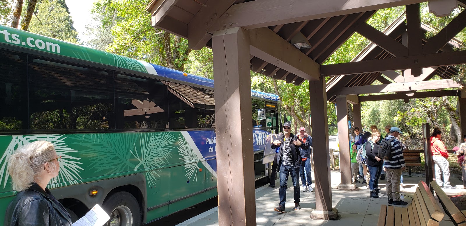
A Yosemite Area Regional Transportation System (YARTS) bus in Yosemite Valley. (Photo by me)
Because Yosemite National Park isn’t in the middle of a densely populated city, many in the U.S. transportation industry would say only bare-bones, lifeline transit service (if that, even) is necessary there. In contrast to DC’s Rock Creek Park, Yosemite lacks a rail system that people who climb El Capitan can use to get back to the bottom of the cliff.  

But a lot of people want to experience Yosemite’s world-class hiking, stunning vistas, and unique alpine scenery. And in recent years, it’s become clear that when too many of the California park’s five million-plus annual visitors attempt to access the park by car, all they’ll experience is misery. During peak periods, drivers can spend hours staring at taillights, only for park rangers to turn them away from the most popular areas before they can even exit their vehicles.

The geometric factors behind the park’s congestion problems mimic those that plague overly auto-dependent cities. Paving over meadows, forests, and streams to build more traffic lanes and parking lots wouldn’t alleviate the crush of cars, though some would-be visitors may find there’s plenty of asphalt to explore in their local strip mall and not even bother to make the trip.

Instead, the solution – just as in cities – is to prioritize more spatially efficient forms of mobility.

The basic elements of this solution are already in place. Core-capacity shuttle services carry per-mile ridership comparable to the country’s busiest transit systems, the regional Yosemite Area Regional Transportation System (YARTS) bus network covers all of the park’s main roads, and walking remains the only way to access backcountry areas.

Improving these options – which I utilized on a recent trip to the park – is the only way to ensure we can preserve and enjoy this precious national treasure.

Most of Yosemite is car-free, and always has been

A view of Yosemite Valley from the Yosemite Falls Trail. (Photo by me)
Despite the traffic congestion plaguing Yosemite Valley (where well-known landmarks including Yosemite Falls, El Capitan, and Half Dome are located) the vast majority of the national park is not accessible by car. The National Park Service (NPS)’s ingenious transportation demand management strategy: not building roads.

Instead, visitors must use the park’s 800 mile network of backcountry trails – which includes portions of the famous Pacific Crest and John Muir trails – to get to Yosemite’s most pristine areas. The trails feature plenty of strenuous sections, but also amenities that would make people in car-choked urban areas envious.

For example, though the top of Half Dome would only be accessible to skilled rock climbers in its natural state, two 400-foot-long cables lining the steepest section of the walkway make it possible for regular hikers to reach the summit. Though the trek still requires strength and stamina, at least hikers on Half Dome – in contrast to cyclists on most city streets in the U.S. – have something more than paint protecting them.

NPS also maintains six High Sierra Camps, each situated along remote sections of backcountry trail. These small communities, catering exclusively to people on foot or horseback, offer hikers cabin lodging and meal service. However, the camps’ accessibility is largely dictated by nature – this summer, for the second time in three years, the facilities won’t operate due to unusually heavy snowfall that prevented employees from conducting pre-season maintenance activities.

To allow visitors “outstanding opportunities for solitude,” NPS regulates Yosemite backcountry mobility much more strictly than it regulates automobile travel in the park (or on DC’s Rock Creek Parkway). Backpackers planning overnight stays in the wilderness must reserve permits months in advance to guarantee access to the highest-demand trailheads during peak tourism periods. Most day hikers are exempt from permitting requirements, though those wishing to attempt the aforementioned Half Dome hike must win a highly competitive NPS lottery before setting foot on the mountain.

Where there are roads, there’s bus service 

A Yosemite Valley shuttle bus crosses a congested road. (Photo by me)
As the acting director of NPS in early 2017, Michael Reynolds fielded an angry phone call from Donald Trump after the agency retweeted photos showing the sparse size of the president’s inauguration crowd. Now, as the superintendent of Yosemite, Reynolds is in charge of the park’s efforts to safely and efficiently handle its record-breaking crowds.

In a 2018 interview with the Fresno Bee, Reynolds provided an excellent summary of the transportation-geometry relationship, explaining that it’s not the large number of visitors to Yosemite Valley that’s the problem, but the fact that many of them are using a form of mobility that there simply isn’t space for.

“The issue here is cars,” the Bee quoted him saying. “An awful lot of cars in a small space, all at one time.”

Reynolds was oddly defeatist, however, when discussing the possibility of better transportation options. According to the Bee article, he said the park “does not have the infrastructure” for a regional bus system providing connectivity between the valley and communities outside the park. He also cringeworthily told the San Francisco Chronicle that an “Uber culture” could help solve the park’s traffic problems.

A Sonora-bound YARTS bus ascends a hail-covered road out of Yosemite Valley. Good thing we weren't driving! (Photo by me)
Fortunately, the superintendent doesn’t need to design a completely new bus system – because one is already there. He’d be well-advised to try that system – YARTS – out sometime.

YARTS started service in 2000, and originally was primarily a lifeline transportation option for park employees. The system, whose four routes operate between Yosemite Valley and the termini of Merced, Fresno, Mammoth Lakes, and Sonora (serving towns, trailheads, and lodging along all of the park’s main roads), still fulfills that essential role. But as it has expanded, park visitors have also used it more and more, with ridership up 50 percent over the last 14 years. Today, more than 100,000 people ride YARTS annually.

Over Memorial Day weekend, I took a day trip on the Sonora route from Rush Creek Lodge (a hotel just outside the park entrance) into Yosemite Valley. Our hour-long mid-morning ride in went smoothly, with the exception of a brief delay to let a bear cross State Route 120. A bus lane through congested portions of the valley aided our travel.

We then hiked for several hours, making it much of the way up the Yosemite Falls Trail. But as we finished our packed-in lunches, thunderclouds loomed. We quickly descended the exposed, switchbacked trail, caught a circulator bus, and headed into The Loft at Degnan’s for a couple beers before catching our afternoon bus back to Rush Creek. By the time we boarded, the weather had deteriorated, but our bus driver calmly and safely ascended the grade out of the valley through an intense hailstorm.  
     
YARTS operates using intercity-style coach buses, with restrooms on board and space for luggage such as hiking and camping gear. Riders can pay their fares when they board – as we did – or can reserve a seat in advance. During particularly busy times of year, the transit system waives fares on some days.

YARTS has made efforts to integrate its transit services with those of peer transportation providers. At the stop in Yosemite Valley, riders can transfer to the aforementioned circulator shuttle system, which has two routes, serves numerous popular destinations, and is fareless. The shuttles are quite crowded, carrying nearly 4,000 passengers per mile of route length – a load factor comparable to that of San Francisco’s Muni. The valley also offers a network of separated bike-pedestrian paths and – starting last year – a dockless bikeshare system.

Outside the national park, YARTS connects to several other regional and intercity transit systems. Riders transferring from Amtrak’s San Joaquins train route (in Merced and Fresno) and Greyhound buses (also in Merced) can purchase through tickets, facilitating travel from locations such as Los Angeles, San Francisco, and Sacramento on a single fare. Also, YARTS offers United Airlines passengers free transfers to YARTS’s Fresno and Mammoth Lakes routes, encouraging visitors flying into Yosemite’s two closest airports that serve major airlines to take the bus to the park. 

And starting next decade, existing YARTS bus routes will connect to the initial operating segment of California’s currently under-construction high-speed rail system in Merced and Fresno, as well as to a Merced extension of the Altamont Corridor Express (ACE) rail system.  
      
While Yosemite has plenty to learn, in the future cities may also learn from Yosemite

Despite all the progress YARTS has made over the last two decades, only two percent of Yosemite visitors arrive by transit, demonstrating that there is a lot of room for improvement.

The existing YARTS system is designed primarily to get people to and from Yosemite Valley, and its timetables strongly resemble those of “commuter” rail or bus systems intended to give people living in outlying parts of metropolitan areas an "alternative" way of getting to and from downtown, with the valley taking the place of the city center. As a result, it can be challenging to plan a transit-based day trip to other must-see (though less car-congested) parts of the park, such as Tuolumne Meadows or Mariposa Grove. Also, the YARTS system is largely seasonal – only the Merced route operates year-round, with service on the other three routes limited to the peak late spring, summer, and early fall tourism periods.

Furthermore, infrastructural issues outside of YARTS’s control limit its ability to serve the region. For example, while (as mentioned earlier) there are bus lanes in Yosemite Valley, there are no such lanes at the park entrances, rendering passengers susceptible to delays caused by long queues of single-occupancy vehicles. Also, NPS does not plow Tioga Pass Road – which carries the Mammoth Lakes route – during snowy periods, preventing YARTS from providing a valuable connection between Yosemite Valley and the famous Mammoth Mountain ski resort during the winter. And the fastest road for automobiles up the Priest Grade, a segment of the Sonora route, is very steep and not maintained to standards adequate for bus service, forcing YARTS riders onto a windier, more circuitous road that’s ten minutes slower.

The view from Rush Creek Lodge, located just outside Yosemite, after a late-May snowstorm. High-elevation weather patterns pose a challenge to transit providers. (Photo by me)
Despite these challenges, plenty of factors indicate a promising future for YARTS.

For one, despite the small percentage of Yosemite visitors that arrive via transit buses, the portion entering the park on any type of bus – including charter buses – is a much greater 9 percent of total entrants, or about 500,000 people. Many of the charter bus passengers could well prefer to take transit – which should offer them more freedom than a guided tour – but may not know YARTS is an option, or may not find the system sufficiently frequent or extensive to meet their needs.

In some ways, YARTS has more going for it than urban transit agencies do. Specifically, improvements to transit in Yosemite – such as increased service frequencies, more year-round service, and routes and schedules designed to facilitate access to all parts of the area roads serve (rather than just Yosemite Valley) – may be less susceptible to the three primary types of harmful transit opposition, as follows:

Car culture:  The auto industry has had a strong influence on American transportation culture, and as a result cars seem to dictate everything from the way our infrastructure is engineered to a person’s social status. Accordingly, many people are hesitant to embrace other methods of getting around.

However, Yosemite is a place people – from urbanists to car aficionados – go to experience the outdoors, not to sit in traffic. For hikers and backpackers, it can be preferable to start and end a trip at different locations (possible by transit) than to return to the origin (required if driving). Furthermore, in contrast to many city centers, people are already accustomed to paying to drive into Yosemite, so tools such as congestion pricing could be framed as beneficial tweaks to the existing toll system. 

NIMBYism:  In metropolitan areas, transit projects connecting major activity centers often face opposition from local residents and business owners who fear change or believe in false stereotypes. This opposition often causes projects to be scaled back, rerouted to the point that their would-be benefits are largely negated, or even cancelled entirely.

But despite how crowded Yosemite can get, only a small number of people live there. Environmental preservationists concerned about impacts on local resources will likely welcome transit improvements and other changes that could reduce driving and help sustain the park’s scenery, rather than oppose those improvements on NIMBY grounds.

Also, in spite of the park’s superintendent’s aforementioned Uber references, the area’s small population and spotty cell phone service render congestion-worsening ride hailing impractical.  

Funding:  New transit infrastructure is expensive to construct, especially in the U.S, and it can be challenging to obtain the necessary funds. However, YARTS service increases would require primarily new buses and drivers, rather than new rights of way, reducing the potential of excessive scrutiny.

Furthermore, California already has relatively good intercity rail and bus service (by U.S. standards), so YARTS can take advantage of infrastructure elsewhere in the state. For example, YARTS hired a consultant to study the possibility of system expansions, but an extension to the San Francisco Bay Area was deemed unnecessary because a well-timed San Joaquins rail connection is already in place. The study instead recommended YARTS prioritize improvements on its existing routes and consider extending its Sonora route to Sacramento via Stockton, which would provide additional connections and help fill a gap in the state’s transportation system.

***

Transit can be a mainstream form of mobility in a national park. The strong ridership on Yosemite Valley’s circulator shuttle system, as well as a comparable local shuttle network serving Zion National Park in Utah (which began service the same year YARTS did, operates as frequently as every four minutes on largely car-free roads, and carries more than 6 million annual riders) demonstrates this.  

However, YARTS has the potential to be a primary way for people to both get to the Yosemite region and move around the region once there, exceeding the Yosemite Valley and Zion systems’ primarily local functionality. To expand transit’s role in the Yosemite area, officials should treat YARTS as they have the park’s backcountry trail network – as mobility, rather than just an alternative to driving and parking. 

If YARTS and the jurisdictions that govern it can seize this opportunity, they not only would help people rediscover Yosemite the way it was meant to be seen, but could also play a part in fixing mobility in other places. If people travel to Yosemite and have positive, car-free transportation experiences there, they may wish to replicate those experiences back home.


Sunday, May 5, 2019

North American border controls make international mobility challenging. How are transit providers coping?


Strasbourg, France's Line D tram, seen here in central Strasbourg, crosses the Rhine River to provide a one-seat connection to the center of Kehl, Germany. (Photo by me)

Within Europe’s Schengen Area, international borders are little more than what they actually are: lines drawn on paper. As a result, transit routes – from local bus and rail services to intercity high-speed trains – can cross these lines without having to slow down or stop.

Border officers have the authority to spot-check passengers’ travel documents, cell phones switch over to a different provider, and depending on the country it may be necessary to exchange currency. But for the most part, the experience is no different than crossing from one U.S. state into another.


For example, Strasbourg, France’s Line D tram crosses the Rhine River to serve Kehl, Germany. While the U.S. capital region struggles to find the funding for a second trans-Potomac Metro tunnel between DC and Virginia, a new trans-Rhine bridge (as seen in my video above) facilitated the line’s cross-border extension. For just a single flat fare, French residents can cross the border for refreshing beer, tasty schnitzel, and relatively inexpensive groceries, while Germans can enjoy Strasbourg’s idyllic canals and historic center or conduct business in the official seat of the European Parliament.

The San Ysidro border crossing facility separating San Diego and Tijuana looks quite a bit different than the tram bridge connecting Strasbourg and Kehl. (Photo courtesy of Times of San Diego)
In contrast to Western Europe, North American policymakers believe that, to ensure the public’s safety, it’s necessary for everyone who legally crosses an international border – be it by land, sea, or air – to stop, queue, and undergo inspection. There’s been a lot of talk about building a wall to mark one of the U.S.’s two land borders, but even at the other (longer) border, these inspections are mandatory for all crossers in both directions.

Even though each individual inspection typically doesn’t take long, at busy checkpoints those extra seconds add up and can cause hours-long waits in line. To make matters worse, many border crossing facilities are designed primarily for cars, and thus incorporate lots of asphalt, congestion, and pollution.

However, a few transit providers have found a way to facilitate functional mobility between the U.S. and Canada or Mexico. Though it’s impossible for these providers to match the efficiency of Schengen countries’ cross-border routes, their offerings do help mitigate the adverse impacts of inspections. Border regions with viable international transit options include San Diego-Tijuana, Detroit-Windsor, and Vancouver-Seattle.

San Diego-Tijuana: transit hubs and pedestrian infrastructure help bring two cities together

The trains don't continue south into Tijuana, but it's still a lot more convenient and pleasant to take transit to the U.S.-Mexico border's busiest crossing than it is to cross in a car. (Photo courtesy of KPBS)
Separating San Diego, California and Tijuana, Baja California, the San Ysidro border crossing is one of the world’s busiest. More than 30 million annual northbound travelers use the crossing to enter the U.S and, though exact data on southbound travelers is not readily available, a comparable number presumably use it to enter Mexico.

The crossing contains inspection facilities for both drivers and pedestrians, and more than a quarter of its users pass through on foot. As a result, public transit connections are essential to the facility’s functionality.

On the San Diego side, the Metropolitan Transit System’s Blue Line trolley (light rail) terminates at the border crossing facility. When U.S.-bound crossers step out of the main customs building, they’re literally on the San Ysidro station’s platform.

San Ysidro is MTS’s busiest non-transfer trolley station and during afternoon rush hour trains are typically packed all the way to the border, helping the Blue Line achieve a farebox recovery ratio of around 75 percent. Given that a transit trip from Mexico to Downtown San Diego takes about 30 minutes and a northward extension of the Blue Line to UC San Diego and the North University City job center is under construction, it’s no wonder that Club Tijuana Xoloitzcuintles de Caliente (the city’s Liga MX soccer team) refers to themselves as El Equipo sin Fronteras.

The Tijuana side of the crossing isn’t quite as transit-friendly, as southbound crossers are greeted by a congested street full of honking, overpriced taxicabs. But it’s still one of the city’s major transportation hubs.  Many microtransit routes stop nearby, as advertised by the La Linea signs in their windows. SITT, Tijuana’s Bus Rapid Transit system, also has a station at the border.

U.S. Customs and Border Protection continues to expand San Ysidro’s capacity to process drivers and pedestrians – PedWest, a second pedestrian crossing facility situated near the Las Americas outlet mall (a short walk or bus ride from the trolley station) opened in 2016 – but border crossers still can face long waits.

Hopes for easing the congestion may rest on encouraging crossers to use other inspection facilities further to the east. Transit improvements, including a rapid bus connecting Downtown San Diego to the Otay Mesa border crossing that began full service earlier this year, as well as privately operated shuttle bus routes connecting the Cross Border Xpress (CBX) pedestrian bridge at Tijuana International Airport to both Downtown and San Ysidro, are an integral part of this strategy.

Detroit-Windsor: a bi-national bus system

Fans ride Transit Windsor's Tunnel Bus to a Detroit Tigers game. (Photo by me)
Like Southern California, Southeast Michigan is incredibly auto-dependent. But Transit Windsor provides a resource San Diegans and Tijuanenses do not have: a local urban bus route that crosses the border. The transit provider’s Tunnel Bus circulates around both Detroit and Windsor’s downtowns, providing a one-seat, cross-border ride to and from numerous central-city destinations. In addition to regularly scheduled operations, special Tunnel Bus services bring border crossers directly to games and other major events.

However, in contrast to San Ysidro, it is not possible to cross between Detroit and Windsor on foot. This may be in part due to geographic limitations – while the San Diego-Tijuana border is a glorified fence, the Detroit River demarcates the Detroit-Windsor border. Currently, there’s no transportation infrastructure connecting the two cities’ downtowns other than a road tunnel, so to add a pedestrian crossing, improvements to the tunnel or a new bridge would be necessary.

Since any local travelers not using car-based transportation must board the Tunnel Bus, the buses are well-used. Despite a construction project that necessitated evening tunnel closures in 2018 and the poor performance of Detroit’s sports teams (which led to poor attendance and, accordingly, fewer people riding transit to the stadiums), more than 180,000 riders utilized the route last year.

However, because the two-lane tunnel does not have a dedicated bus lane, during busy periods buses often move more slowly than riders could walk . If the delays get too severe (as happened when I rode last summer) buses may short-turn, forgoing much of their regular downtown routing to return straight back across the border a few minutes closer to schedule.
 
Once through the tunnel, the bus pulls up to the border inspection facility, where all passengers must disembark. There’s no point in rushing to be the first person in the passport control queue, as cleared Tunnel Bus passengers entering the Motor City are herded straight back onto the bus. Even if the rider’s destination is adjacent to the border crossing, they must wait until every single rider has cleared inspection and re-boarded, after which the bus proceeds forward about fifty feet to its first Detroit stop.   

Vancouver-Seattle: an intercity rail line treated like air travel  

An Amtrak Cascades train in Vancouver, BC's Pacific Central Station. The fence separates platforms serving Amtrak trains to and from the U.S. from those serving domestic Via Rail trains. (Photo courtesy of Davidspix)
Amtrak offers three cross-border routes, all of which serve Canada. (Mexico’s national intercity passenger rail system all but ceased operation after the country privatized its tracks in the 1990s, though in recent years there’s been a push to rejuvenate some regional service.)

The Adirondack and Maple Leaf routes, which connect New York to Montreal and Toronto respectively, are treated similarly to other forms of cross-border surface transportation – at the border, the train stops and passengers undergo inspection either onboard or at an adjacent passport control facility. The train doesn’t start moving again until all passengers – as well as the railcars themselves – have cleared inspection, a process that can take as long as two hours (and took nearly ten minutes just for Amtrak to explain on video). By comparison, westbound TGV trains crossing the France-Germany border at Strasbourg pull into Paris, 300 miles away, after that amount of time.

But the third cross-border route – Amtrak Cascades, which connects Vancouver and Seattle and continues to destinations farther south, including Portland and Eugene, OR – is treated more like U.S.-Canada airline flights are.

Because there are no scheduled stops between Vancouver and the Canadian border, passengers traveling in both directions clear passport control at a facility in Vancouver’s station. As a result, they enjoy shorter, more reliable travel times. (Southbound trains currently have to stop briefly at the border for a secondary customs check, though efforts are underway to consolidate this check into the existing process at Vancouver and allow the train to cross into the U.S. at track speed.)

A similar passport control facility is also planned for Montreal’s station. Once it opens, Adirondack trains will have to bypass their only intermediate Canadian stop, Saint-Lambert, though intercity Via Rail and suburban Exo trains will still serve that station. The new facility is expected to help catalyze an extension of the Vermonter route (which currently operates between Washington, DC and St. Albans, VT) to Montreal.

Are international borders just lines, or do they mean something more?

A South Korean track inspection train crosses the Demilitarized Zone into North Korea in November 2018. It was the first train to cross between the two Koreas since 2008. (Photo courtesy of The Korea Times)
Worldwide, the North American approach to border control remains much more common than the Schengen approach. For example, travelers between the Schengen Area and United Kingdom have always had to undergo border inspections, even before all the Brexit drama. People using Eurostar high-speed trains to make that trip pass through pre-clearance facilities in their originating station, much as U.S.-bound Amtrak Cascades riders do in Vancouver.

For rail riders traveling eastbound out of the Schengen Area into ex-Soviet countries such as Belarus or Ukraine, the process is even more complex. Not only do border inspections take place, but the respective countries’ railroad tracks are built to different gauges. Thus, the trains’ bogies (wheels and axles) must be swapped at an exchange facility, or passengers must transfer to a different trainset to complete their trip.

And on the other side of Eurasia, a combination of geography and politics has rendered South Korea’s transportation system, though excellent for domestic purposes, comparable to those of island nations when it comes to international mobility. While an occasional test train may cross the DMZ during periods of relative détente, for all practical purposes the only way in or out of the country is by air or sea.

People protesting a Donald Trump rally in San Diego during the 2016 presidential campaign pass in front of a Blue Line train bound for San Ysidro and the border crossing to Tijuana. (Photo by me)
But it’s certainly possible that more countries will reach Schengen-like border agreements in the future. In North America, the U.S. and Canada already have a bilateral relationship that, border controls notwithstanding, is comparable to those the Schengen countries enjoy.

And while the current political climate may make easier U.S.-Mexico mobility (and an extension of San Diego’s Blue Line into Tijuana) difficult to imagine, just 80 years ago a cross-border tram line connecting France and Germany must have seemed even more of a fantasy as World War II loomed.


Monday, April 1, 2019

“Failed” California, “Self-interested” France: Texas Central Railway gets down and dirty

Amtrak's three-day-per-week Sunset Limited passes a sugar mill in Texas. In the future, the route will offer connections to both the Texas Central Railway (in Houston) and California High-Speed Rail (in Los Angeles). (Photo courtesy of SWRails.com) 
I'd planned to post some April Fools' satire today, perhaps about Duke blaming WMATA-caused electromagnetic interference for its Elite Eight loss to Michigan State at DC's Capitol One Arena.

But while working on a Mobility Lab piece about intercity rail, I came across something equally absurd – but entirely real. Texas Central Partners, the company planning to construct a high-speed rail line linking Dallas and Houston, is to thank.

Private-sector companies like Texas Central have great potential to help improve U.S. intercity rail, as I’ll explore in the upcoming Mobility Lab article. But the company’s March 18 blog post blasting rail systems in France and California demonstrates that Texas Central has a lot to learn if it wants to reach its potential.

***

The issue at hand was pretty straightforward. Texas Central plans to use Japanese Shinkansen technology for its trainsets and tracks, a decision that I trust officials made after concluding that particular technology is the best fit for the Dallas-Houston route. Shinkansen trains have certainly done right by Japan, so I’m confident they’ll serve the Lone Star State well too.

But the U.S. subsidiary of SNCF, France’s national rail provider, also had hoped to build a high-speed rail system in Texas. So after Texas Central received a big loan from Japanese entities last year, SNCF publicly questioned several aspects of Texas’s privately-financed project plan.

SNCF America had some legitimately constructive criticism – namely, the proposed Texas Central system would leave much of the state, including major cities such as San Antonio and Austin, without improved rail connections. And given a lack of interoperability with existing conventional lines, Texas Central’s plan offers no feasible way to extend frequent train service to those cities in the near term.

But a more extensive, integrated rail system may require taxpayer funds to construct, something that would be extremely challenging to obtain in a state where Beto O’Rourke couldn’t beat Ted Cruz.

***

Texas Central could have responded by framing its market-based approach as a uniquely Texan way to navigate the typical American hurdles and get a big infrastructure project done.

But instead, Texas Central’s blog post began by ripping into not only SNCF, but the entire “European model” for intercity rail service. The post claimed that the TGV and other high-speed systems on the continent are little more than government conspiracies to fleece taxpayers. It also mocked the aging infrastructure-associated challenges European rail systems contend with, without specifying how Texas Central plans to address those same challenges when they arise in the future.

Then, though California wasn’t involved in the debate between Texas Central and SNCF, the company's post attacked that state’s under-construction high-speed rail system. It even embraced the opponent-concocted lie that because Governor Gavin Newsom decided to take a more segmented approach to the project than his predecessors did, the project has failed.

***

Texas Central and newly hired Cal Bears basketball coach Mark Fox find themselves in comparable positions. Fox inherited a Cal team that finished dead last in the Pac-12 Conference each of the last two seasons and got blown out by the likes of Yale and Chaminade.

Similarly, though Texas would be the 10th largest economy in the world if it were its own country, the state currently lacks any intercity passenger rail lines that run more than once per day. The three routes that serve the state – all operated by Amtrak – all ran late more than half the time in Fiscal Year 2018. And there’s no existing direct train service on the Dallas- Houston corridor Texas Central plans to serve.

Just as I hope Fox can lead the Golden Bears back to March Madness, I’m rooting for Texas Central to help fix the state’s inadequate rail system. But the attitude of the company – which has yet to lay an inch of track – is akin to if Fox claimed Cal’s team is superior to those in this year’s Final Four:
  • France has nearly 1,700 miles of high-speed rail tracks, and more than 130 million passengers ride TGV trains annually. A 2007 TGV test run on the LGV Est line reached 357 mph, a world record for a wheels-on-rails trainset that still stands today. While Texas landowners desperately try to fight off the threat of a border wall, the TGV system seamlessly extends into several neighboring countries. And I imagine Texans would approve of France’s plans to open up its national rail network to private-sector competition in 2021.
  • California’s train system isn’t in the same league as France’s, but the state does boast three intercity rail corridors with frequent service by U.S. standards, along with four long-distance routes. The corridors all rank among the country’s seven most utilized, achieved on-time performances of better than 75 percent in FY 2018, and are complemented by an extensive network of connecting buses. Furthermore, large-scale high-speed rail construction is underway in the state’s Central Valley, and private-sector rail operator Brightline (owned by UK-based Virgin Rail Group) is planning to build a line linking Southern California and Las Vegas.
In its arrogance, Texas Central forgot that if its peers succeed, it benefits. The propagation of high-speed rail across most of the developed world is largely thanks to the success of older services like the Shinkansen and TGV – if those systems didn’t exist, Texas Central likely wouldn’t either. Similarly, once California’s initial operating segment proves itself, other states will beg for similar intercity mobility, giving companies like Texas Central opportunities to expand across the country. 

Also, the Texas and California routes will be part of the same national train system, making their future performance even more mutually dependent. Texas Central has already reached a through-ticketing agreement with Amtrak, which provides one-seat rail service between Los Angeles and both Dallas and Houston. As part of the agreement, Texas Central even plans to shuttle transferring passengers between the two providers’ respective stations.

***

Just as with local transit, high speed rail providers in different parts of the world must embrace what works for the regions they serve. This means that trainsets, route alignments, and funding structures will differ from region to region. But as long as the end product moves people safely, reliably, and efficiently, there’s no single right or wrong way to provide rail service.

However, in its response to SNCF, Texas Central sounded more like the Koch-funded Cato Institute (which, unsurprisinglyopposes the Dallas-Houston project) than like a transit provider-to-be.

Since Texas Central is relatively new to the rail business, it should treat this incident as a mistake it can learn from. The company clearly is ambitious, as anyone trying to build a modern intercity rail line in such untested territory must be, and has high hopes for its product.   

Thus, to restore the public’s confidence that it’s serious about getting the project done and mend its relationships with its peer high-speed rail providers, Texas Central’s should delete its March 18 blog post. The company should replace that post with a thoughtful article explaining why its current approach is the best way to navigate Texas’s development patterns, political climate, and culture; deliver top-notch Dallas-Houston train service; and eventually expand to more corridors, both within the state and nationwide.

Saturday, March 23, 2019

A two-block bike lane brought out the best – and worst – of neighborhood-level politics


DDOT has proposed contraflow bike lanes for both blocks of Woodley Place, which parallels Connecticut Avenue in Northwest DC. (Photo by me)
To read my planned public comments on the proposed Woodley Place bike lane, click here. I’d planned to present these comments to DC’s Advisory Neighborhood Commission 3C at the March 18, 2019 meeting but was unable to do so due to time constraints, as described below.
 
It might be the simplest transportation project in American history.

Currently, there’s no safe or comfortable way to bike from DC’s Cleveland Park (where I live) and other parts of Upper Northwest to or from Adams Morgan, the U Street corridor, and central parts of the city. As a result, a lot of cyclists ride on busy streets, such as Connecticut Avenue, or on sidewalks, creating dangerous conflicts with drivers and pedestrians. 

Fortunately, calmer Woodley Place parallels Connecticut through the Woodley Park neighborhood. The two-block street carries few cars, because one block allows only northbound travel and the other only southbound travel. Though cyclists also can’t legally travel the length of Woodley Place, plenty of us – including myself – regularly choose the route over its legal, but more dangerous alternatives. 

The District Department of Transportation (DDOT) has proposed an obvious alignment of law and safety: contraflow bike lanes on both blocks of Woodley Place that will allow cyclists to proceed through. Because the road’s existing travel lane is unusually wide, DDOT will just convert that lane into one of normal width, allow contraflow cyclists to use the excess street space, and preserve all the existing capacity parkers and drivers enjoy. In fact, due to a quirk of the street’s design, there will actually be more space for people to park their cars once the project is complete.

But though the bike lane project might be straightforward and logical, politics – and the human interaction it entails – never are.

A cyclist on Connecticut Ave pedals past the Cleveland Park Library, where Monday's Advisory Neighborhood Commission 3C meeting took place. (Photo courtesy of Gilbane Building Company).
The March 18, 2019 Advisory Neighborhood Commission (ANC) 3C meeting, which featured discussion of the proposed Woodley Place bike lane, ended in a successful draw but was a mobility-vs-NIMBY showdown to remember. (The second link includes video of the meeting’s bike lane discussion).

DC has 40 different ANCs, covering the entire city. Each consists of commissioners who serve two-year terms, are chosen in the general November elections, and represent around 2,000 residents.

ANCs don’t have any hard power. But their resolutions, which advise and provide recommendations to city agencies, can have substantial influence. For example, a group of ANCs along the 14th Street Corridor worked together to help start WMATA’s limited-stop Route 59 bus. And some of DC’s most influential politicians, including Mayor Muriel Bowser and Councilmember Jack Evans (who also chairs the WMATA board), got their starts as ANC commissioners.

So last Monday night, the DC transportation world’s eyes were on the Cleveland Park Library. I rode a Capital Bikeshare bike from my downtown office, up Woodley Place, and into the docks right outside the library. Electricity was in the air as attendees streamed into the meeting room.

Proponents of the bike lane comprised the majority of the standing-room-only crowd, but like fans at a title fight they had to wait a while for the meeting’s main event. As the nine 3C commissioners worked through the agenda, which included a monthly crime report from a Metropolitan Police Department lieutenant (apparently, MPD recently stepped up its presence in our neighborhood due to a series of car break-ins) and discussion on a planned apartment complex redevelopment, anticipation built.

Then, the moment arrived. Officials from DDOT kicked off the bike lane discussion with a presentation on the city’s proposal. After the presentation concluded, it was time for public comments.

Supporters of the Woodley Place bike lane line up to speak at Monday's Advisory Neighborhood Commission 3C meeting. Opponents of the lane formed a separate line, which was not long enough to be visible in this photo. (Photo by me) 
ANC 3C Chairperson Nancy MacWood’s format for the meeting’s public comment portion made me wonder if she’d manufactured the participation trophy I received for playing outfield on Davis, CA Little League’s one-win Zephyr in 2001.

Though the vast majority of meeting attendees wore stickers supporting the bike lane proposal, MacWood declared that one of every two comments must oppose the lane. After listening to the first few speakers, MacWood ordered attendees for and against the bike lane to form two separate lines and exchange the mic. The line of proponents extended the length of the center aisle and wrapped around the back of the room. Four or five opponents rose to face them.

Things heated up. When an opponent complained that the Woodley Place project may set precedent for DDOT to further expand the area’s bike lane network, supporters erupted in cheers, excited about this prospect. When a proponent speculated that some Woodley Place residents don’t want bike lanes primarily because parking illegally on the street will become more challenging, opponents in the crowd fumed and seemed ready to physically fight him.

Then, as I stood second in line, and with a couple dozen more bike lane supporters waiting behind me, MacWood abruptly closed comments, citing time constraints. Almost on cue, loudspeaker announcements warned attendees that the library would be closing at 9pm. With the clock winding down, it was time for ANC 3C to consider the issue at hand.

Lee Brian Reba, who represents the district that Woodley Place lies in (3C01), introduced a resolution calling for the bike lane’s paralysis-by-analysis. Reba had collaborated with Woodley Place residents – minus the 140 people who live at the Calvert Woodley Apartments – to craft his resolution. Jimmy Dubois, hailing from 3C03, then seconded Reba’s resolution but introduced an amendment – one that would strike all of Reba’s text and replace it with wording supporting the lane. Beau Finley, who represents 3C04 (my district), quickly seconded Dubois’s amendment.

Then, right before the vote, came the bombshell that would dominate conversation during the post-meeting celebration at local watering hole Nanny O’Briens: Commissioner Angela Bradbery recused herself due to a financial conflict of interest. Bradbery’s partner tutors a student who lives on Woodley Place and the student’s anti-bike lane parents had made a point of asking who Bradbery, a swing vote, would side with.

With Bradbery sidelined, it was up to the remaining eight commissioners to determine who would win the night. First up was Dubois’s pro-bike amendment: a 4-4 tie, short of the majority required to pass. Then, Reba’s original anti-bike resolution also drew 4-4.

But as in a group-stage soccer match, a draw is never actually a draw. And on this night, the goal differential was in our favor. Because ANC 3C couldn’t comment on the bike lane, DDOT can proceed with its proposed fix for Woodley Place without interruption.

Minutes later, the taps across the street at Nanny’s were flowing. As cycling advocates and pro-bike lane ANC commissioners enjoyed themselves and started planning for the next battle, a blank-faced Reba sulked at a nearby table with 3C08 Commissioner and fellow project opponent Maureen Boucher, munching on a quesadilla. 
  
A plane sprays mosquitoes in Davis, CA in August 2006, due to concerns about West Nile Virus. The previous year, protesters opposing insect spraying took over a City Council meeting. (Photo courtesy of Davis Wiki)
Last Monday’s ANC 3C meeting brought back memories from my youth of the legendary 2005 Davis City Council.

Led by icons including Ruth Uy Asmundson and Sue Greenwald, the city held a series of epic public hearings in June (at which everyone wishing to comment was able to) on Covell Village, a proposed mixed-use development project that would later fall short at the ballot box. Two months later, meeting attendees hijacked a Q&A session on West Nile Virus mosquito spraying, running Mayor Asmundson and a panel of experts she’d convened out of the community’s chambers. The protesters helped spare that year’s mosquitoes, but after four more Yolo County residents caught the virus the next summer, pesticide-spraying planes would roar over the town.

Those memories reinforced the fact that no matter how much work we do to craft the perfect transportation solution, civil engagement like Monday night’s determines the fate of many important projects. Transportation progress will always require navigating the absurdity of politics, from neighborhood commissions up to @realDonaldTrump.
          
Sure, special interests do everything they can to buy people off and otherwise manipulate the political process.

But in the end, pure will can win the day.